Share R3 Zoning District Update on FacebookShare R3 Zoning District Update on X (formerly Twitter)Share R3 Zoning District Update on LinkedinEmail R3 Zoning District Update link
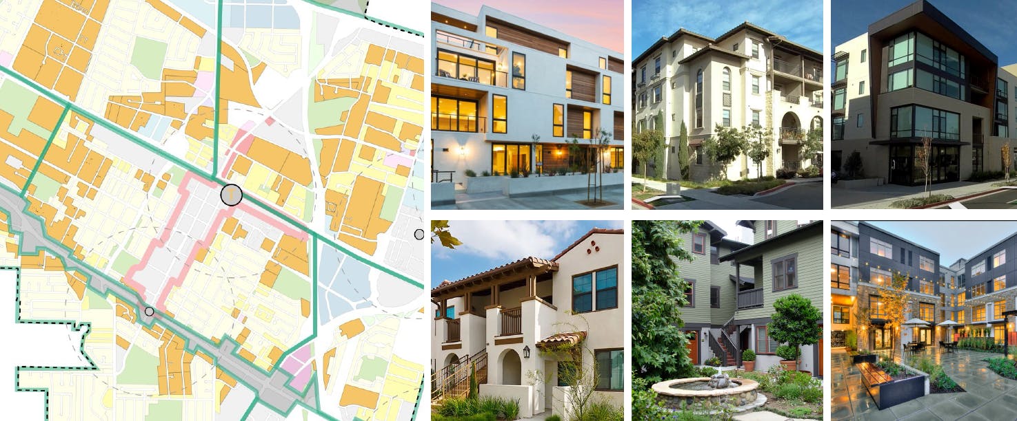
The R3 Zoning District (and the Precise Plans that utilize R3 development standards) covers approximately 15% of the City’s area and contains approximately 50% of the City’s existing dwelling units. It is characterized by a broad diversity of housing types, including single-family, apartments, condominiums, rowhouses, townhouses, and duplexes. It also includes a small number of other uses, such as churches. A map of the R3 District is available here.
The City Council’s work plan includes revisions to the R3 Zoning District to consider form-based standards, incentivizing stacked flats, and updated rowhouse design guidelines.
On April 9, 2024 the City Council identified the following goals for the project:
Create opportunities for diverse unit types, including middle-income ownership and stacked flats.
Produce better design that reflects the community’s vision through objective form-based standards such as pedestrian-friendly streetscapes, respectful transitions in building size, and more trees/landscaping.
Create opportunities for neighborhood-serving uses.
Respond to State and Housing Element requirements.
Change density in targeted areas to achieve desired goals, implementing changes to large parcel areas rather than small, and increasing the supply of housing.
Consider a series of incentives for developers that are more attractive than the State density bonus.
Encourage parcel assembly.
On March 25, 2025, the City Council provided direction on the project, including where to target increased densities in the R3 Zoning District and, pursuant to Housing Element Program 1.3.h, in what locationsR2 properties should be upzoned to R3. This direction was modified on June 24, 2025.
On February 10, 2026, the City Council provided feedback on the draft code amendments, retail and live-work approach, multi-family parking standards, incentive for parcel assembly, nonconforming code updates, and inclusion of the R4 Zoning District in the project.
In addition, the R3 Zoning District Update may proactively address programs in the City’s 2023-2031 Housing Element. This plan was adopted by the City in April 2023, and itidentifies the City’s current housing conditions and future housing needs while outlining initiatives to improve available housing for populations with various income levels within the City.
Next Steps
Staff is preparing the final ordinance text based on the City Council's direction. Adoption is tentatively scheduled for Q3/Q4 2026.
Provide comments about the draft “Change Areas” based on previous Council direction, where you think other R3 “Change Areas” should be considered, or other comments regarding heights or densities in these areas.
Provide comments about the draft R2 rezoning areas, where you think other R2 rezoning areas should be considered, or other comments regarding heights or densities in these areas.
Provide other comments about the R3 Zoning District Update.
The deadline to provide comments to the EPC through this webpage is February 9, 2025. The deadline to provide comments to the City Council through this webpage is March 2, 2025. After these dates, provide your comments by emailing the project contact, epc@mountainview.gov, or citycouncil@mountainview.gov, or speak during the public comment section at the upcoming meetings.
CLOSED: This discussion has concluded.
Why not rezone the tract between Caltrain and Evelyn Ave and Castro and Steven’s Creek, particularly 100-200 Evelyn Ave to R3 6 stories with Retail/Commercial on the ground floor and Residential above? You could even allow 1 or 2 paring levels above the ground floor to provide more separation from the railroad noise for the resi. Right now these buildings seem to have a lot of vacancy, yet they are in a prime location for transit and pedestrian access to Castro St.
The Caltrain parking could also be structured with retail at ground and resi above. I realize that Caltrain may own some or all of this land, but I believe that part of the purpose of the Caltrain JPB is to promote this type of transit oriented development.
Steve M
Over 1 year ago
Hi. As an avid (but aging) bike rider, I am appalled by the distances I have to travel and the obstacles I need to negotiate to shop for food, take a yoga or music class, or see a dentist, or eat out. As a result, I drive a lot more than I would *like* to.
The issue, of course, is zoning. Granted, heavy industry pollutants should not be next to homes or schools. But there are a world of businesses that can easily coexist with dwelling space, that would make life more convenient for every, and get cars off the road.
I'm disappointed to see that this "R3" zoning project does make allowances for anything of the kind--so everyone living there will have to do just much driving as they do now.
I'd be happy to be wrong. I haven't read the full proposal, just the summary above. But the idea of "multi-family dwellings" is generally supposed to ease housing pressure. But if everyone has a car, and everyone is driving, those that can afford to will avoid the place.
As they're going to drive anyway, they'll opt for lower housing density. But if it were *convenient* to walk to a pub and other utility destinations, they might well opt for that locale--and hob nob with multiple stratas of society in the process, which would benefit us all.
Aeric
Over 1 year ago
Does this project includes the possibility of taking properties such as our single family home through emanate domain or other methods to build denser housing? Can you state definitely that this will not involve taking homes from homeowners? And that the impact of the decisions only applies to new building and development? Since the information is about goal and doesn't identify the tools the city will an will not use it is not clear. It is confusing to me, my family and other home owners in the area if
grahamP
Over 1 year ago
If we truly intend to plan for a more sustainable and equitable future, then removing ownership housing from consideration only hinders our ability to adapt. People keep noting that zoning changes don’t happen often. We should take this chance to plan for the decades ahead, rather than assume current uses or ownership structures will remain fixed.
David Watson
Over 1 year ago
Upzoning some of the proposed Cuesta Park Streets to R3 would create serious issues for safety, infrastructure, and neighborhood character. Here’s why:
Massive Scale Mismatch – Proposed 4-story buildings (what you get with density bumps) will dwarf adjacent 1-story homes. The small 5,500 sq. ft. lots on Nilda mean rear setbacks won’t prevent these structures from overwhelming existing homes. Severe Sunlight & Privacy Loss – Bonita buildings will block all afternoon sun by 2 PM, leaving Nilda backyards in full winter shade. Residents will lose privacy as towering units loom over fences. Traffic & Parking Nightmare – Bonita is already Cuesta Park’s densest street. Adding 100+ units (200+ cars) without parking will lead to extreme congestion. No alternative parking exists—Bonita dead-ends, and Hans & El Camino can’t absorb the overflow. Loss of Neighborhood Character – This area is a quiet, single-family neighborhood, not a transit hub. Cramming R3 developments into a low-density street with no overflow options is a real burden on neighbors.
This upzone is misaligned with the city’s stated goals of transit-oriented, well-integrated housing growth. Instead of a blanket R3 designation, the city should consider more appropriate, gradual density increases (e.g. one side of Bonita is R3 and the other is R2.5) that respect Cuesta Park’s scale and infrastructure.
Would love to discuss this further and explore smart growth alternatives that balance housing needs with livability for current and future residents.
andersonsteve
Over 1 year ago
I understand it is unlikely condos and rowhome areas will be redeveloped. So it doesn't maybe make sense to count these areas towards RHNA - but I don't see the sense in excluding these areas from higher density zones only for that reason. Zoning changes only happen once in a few decades, after all. There is a non-zero chance within that time some one or two of these areas will build homes - but only if we let it happen!
Anywhere that makes sense should have higher density zoned
Isaac Stone
Over 1 year ago
I think it's great the city is looking at how to make housing more affordable and I want to share my appreciation for all the time and thought you're putting into this. My big concern is safety and not making parking and traffic worse than it already is. Two of the streets that are chosen- Bonita and Boranda (and I'm sure others I'm not familiar with) are streets elementary and middle school students are crossing to get to school. Putting so much more traffic on those roads that have one main outlet (El Camino) concerns me for their safety. The city should watch one morning or afternoon what this looks like so they understand the number of kids using these routes. Additionally, parking is already an issue on those streets and spills over onto surrounding streets. It's nice to think people won't have a car but I don't believe we're there yet. We don't have a transit system in that area to support that change. So I would proceed cautiously. Try one or two of these in different areas, please don't put a lot of them on one street.
Mt View citizen
Over 1 year ago
It seems like not very many R2 parcels are being converted to R3. Why not convert the parcels downtown and next to the Caltrain station?
Daniel Hulse
Over 1 year ago
My general comments is that I support the densification effort, but it's not clear why these parcels were chosen for change. As long as we aren't doing a uniform densification you would want, parcels should be densified more in proximity to train stations and high-quality bus routes (ECR, VTA Orange Line, Caltrain). Right now, it seems like we're fine allocating R3 to areas next to freeways and highways that subject tenants to environmental pollution in the form of tire particulates--exactly the kind of land use conflict that is supposed to avoid. If we're fine subjecting tenants to that, why aren't we also fine with subjecting homeowners in high-resource areas (downtown, south of el camino etc) to living next to tall buildings? Fairness means we shouldn't be exempting certain people from change just because they have more resources to complain. Additionally, the whole point of zoning (as opposed to precise plans) is just letting the chips fall where they may and not having to micromanage development. So overall I support a more uniform densification for the sake of fairness, and especially more density in transit-supporting parcels.
Daniel Hulse
Over 1 year ago
I’d also echo the comment about more high density residential near the CalTrain stations. Really I can’t imagine any upper limit on height within a 5 or 10 minute walk from a Caltrain station, considering the billions the state is spending on building and improving that infrastructure.
David W
Over 1 year ago
I think it's great the city is looking at densifying and reducing barriers to building more/taller/higher. I support of reduced parking requirements and more "walkable" feel -- though I recognize this is hard to do given how car-centric Silicon Valley is. Are there parallel efforts to improve walk/bike-ability and ensure high frequency transit? Is there additional densification possible near the two Caltrain stations?
Bryan L
Over 1 year ago
Love that we're doing this and I think we should go denser, above 12 stories and remove any parking requirements. Make it all mixed use and have other regulations about noise and pollution keep businesses in check. Density is the #1 way we can improve housing costs, reduce traffic and build a better Mountain View!
Ryan Doherty
Over 1 year ago
Please ensure sufficient parking requirements on the new builds to not overly burden the existing neighborhood. Additionally, some thought on solar panels shading on the immediate neighbors should be looked at as well.


Why not rezone the tract between Caltrain and Evelyn Ave and Castro and Steven’s Creek, particularly 100-200 Evelyn Ave to R3 6 stories with Retail/Commercial on the ground floor and Residential above? You could even allow 1 or 2 paring levels above the ground floor to provide more separation from the railroad noise for the resi. Right now these buildings seem to have a lot of vacancy, yet they are in a prime location for transit and pedestrian access to Castro St.
The Caltrain parking could also be structured with retail at ground and resi above. I realize that Caltrain may own some or all of this land, but I believe that part of the purpose of the Caltrain JPB is to promote this type of transit oriented development.
Hi. As an avid (but aging) bike rider, I am appalled by the distances I have to travel and the obstacles I need to negotiate to shop for food, take a yoga or music class, or see a dentist, or eat out. As a result, I drive a lot more than I would *like* to.
The issue, of course, is zoning. Granted, heavy industry pollutants should not be next to homes or schools. But there are a world of businesses that can easily coexist with dwelling space, that would make life more convenient for every, and get cars off the road.
I'm disappointed to see that this "R3" zoning project does make allowances for anything of the kind--so everyone living there will have to do just much driving as they do now.
I'd be happy to be wrong. I haven't read the full proposal, just the summary above. But the idea of "multi-family dwellings" is generally supposed to ease housing pressure. But if everyone has a car, and everyone is driving, those that can afford to will avoid the place.
As they're going to drive anyway, they'll opt for lower housing density. But if it were *convenient* to walk to a pub and other utility destinations, they might well opt for that locale--and hob nob with multiple stratas of society in the process, which would benefit us all.
Does this project includes the possibility of taking properties such as our single family home through emanate domain or other methods to build denser housing? Can you state definitely that this will not involve taking homes from homeowners? And that the impact of the decisions only applies to new building and development? Since the information is about goal and doesn't identify the tools the city will an will not use it is not clear. It is confusing to me, my family and other home owners in the area if
If we truly intend to plan for a more sustainable and equitable future, then removing ownership housing from consideration only hinders our ability to adapt. People keep noting that zoning changes don’t happen often. We should take this chance to plan for the decades ahead, rather than assume current uses or ownership structures will remain fixed.
Upzoning some of the proposed Cuesta Park Streets to R3 would create serious issues for safety, infrastructure, and neighborhood character. Here’s why:
Massive Scale Mismatch – Proposed 4-story buildings (what you get with density bumps) will dwarf adjacent 1-story homes. The small 5,500 sq. ft. lots on Nilda mean rear setbacks won’t prevent these structures from overwhelming existing homes.
Severe Sunlight & Privacy Loss – Bonita buildings will block all afternoon sun by 2 PM, leaving Nilda backyards in full winter shade. Residents will lose privacy as towering units loom over fences.
Traffic & Parking Nightmare – Bonita is already Cuesta Park’s densest street. Adding 100+ units (200+ cars) without parking will lead to extreme congestion. No alternative parking exists—Bonita dead-ends, and Hans & El Camino can’t absorb the overflow.
Loss of Neighborhood Character – This area is a quiet, single-family neighborhood, not a transit hub. Cramming R3 developments into a low-density street with no overflow options is a real burden on neighbors.
This upzone is misaligned with the city’s stated goals of transit-oriented, well-integrated housing growth. Instead of a blanket R3 designation, the city should consider more appropriate, gradual density increases (e.g. one side of Bonita is R3 and the other is R2.5) that respect Cuesta Park’s scale and infrastructure.
Would love to discuss this further and explore smart growth alternatives that balance housing needs with livability for current and future residents.
I understand it is unlikely condos and rowhome areas will be redeveloped. So it doesn't maybe make sense to count these areas towards RHNA - but I don't see the sense in excluding these areas from higher density zones only for that reason. Zoning changes only happen once in a few decades, after all. There is a non-zero chance within that time some one or two of these areas will build homes - but only if we let it happen!
Anywhere that makes sense should have higher density zoned
I think it's great the city is looking at how to make housing more affordable and I want to share my appreciation for all the time and thought you're putting into this. My big concern is safety and not making parking and traffic worse than it already is. Two of the streets that are chosen- Bonita and Boranda (and I'm sure others I'm not familiar with) are streets elementary and middle school students are crossing to get to school. Putting so much more traffic on those roads that have one main outlet (El Camino) concerns me for their safety. The city should watch one morning or afternoon what this looks like so they understand the number of kids using these routes. Additionally, parking is already an issue on those streets and spills over onto surrounding streets. It's nice to think people won't have a car but I don't believe we're there yet. We don't have a transit system in that area to support that change. So I would proceed cautiously. Try one or two of these in different areas, please don't put a lot of them on one street.
It seems like not very many R2 parcels are being converted to R3. Why not convert the parcels downtown and next to the Caltrain station?
My general comments is that I support the densification effort, but it's not clear why these parcels were chosen for change. As long as we aren't doing a uniform densification you would want, parcels should be densified more in proximity to train stations and high-quality bus routes (ECR, VTA Orange Line, Caltrain). Right now, it seems like we're fine allocating R3 to areas next to freeways and highways that subject tenants to environmental pollution in the form of tire particulates--exactly the kind of land use conflict that is supposed to avoid. If we're fine subjecting tenants to that, why aren't we also fine with subjecting homeowners in high-resource areas (downtown, south of el camino etc) to living next to tall buildings? Fairness means we shouldn't be exempting certain people from change just because they have more resources to complain. Additionally, the whole point of zoning (as opposed to precise plans) is just letting the chips fall where they may and not having to micromanage development. So overall I support a more uniform densification for the sake of fairness, and especially more density in transit-supporting parcels.
I’d also echo the comment about more high density residential near the CalTrain stations. Really I can’t imagine any upper limit on height within a 5 or 10 minute walk from a Caltrain station, considering the billions the state is spending on building and improving that infrastructure.
I think it's great the city is looking at densifying and reducing barriers to building more/taller/higher. I support of reduced parking requirements and more "walkable" feel -- though I recognize this is hard to do given how car-centric Silicon Valley is. Are there parallel efforts to improve walk/bike-ability and ensure high frequency transit? Is there additional densification possible near the two Caltrain stations?
Love that we're doing this and I think we should go denser, above 12 stories and remove any parking requirements. Make it all mixed use and have other regulations about noise and pollution keep businesses in check. Density is the #1 way we can improve housing costs, reduce traffic and build a better Mountain View!
Please ensure sufficient parking requirements on the new builds to not overly burden the existing neighborhood. Additionally, some thought on solar panels shading on the immediate neighbors should be looked at as well.